


Craigsville, VA
Craigsville, VA 24430
Craigsville Map
Craigsville is a town in Augusta County, Virginia, United States. The population was 979 at the 2000 census. It is part of the Staunton–Waynesboro Micropolitan Statistical Area.
Craigsville is located at 38°4?46?N 79°22?52?W / 38.07944°N 79.38111°W / 38.07944; -79.38111 (38.079439, -79.381224).
According to the United States Census Bureau, the town has a total area of 2.0 square miles (5.1 km²), all of it land.
Nearby cities include Greenville, Churchville, Staunton, Stuarts Draft, Deerfield.
Places in Craigsville
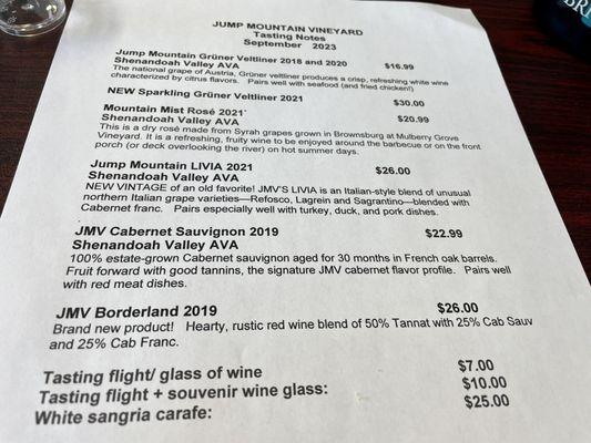
Dine and drink
Eat and drink your way through town.


Can't-miss activities
Culture, natural beauty, and plain old fun.


Places to stay
Hang your (vacation) hat in a place that’s just your style.


See a problem?