Hornitos, CA
Hornitos, CA Map
Hornitos is a US city in Mariposa County in the state of California. Located at the longitude and latitude of -120.238333, 37.502222 and situated at an elevation of 257 meters. In the 2020 United States Census, Hornitos, CA had a population of 38 people. Hornitos is in the Pacific Standard Time timezone at Coordinated Universal Time (UTC) -8. Find directions to Hornitos, CA, browse local businesses, landmarks, get current traffic estimates, road conditions, and more.
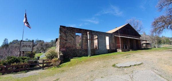
Hornitos, California, is a small, unincorporated community that offers a glimpse into the rich tapestry of the American Gold Rush era. Known for its historical significance, Hornitos was once a bustling mining town in the mid-19th century. Today, it stands as a preserved reminder of the past, with its rustic charm and remnants of old structures. The town's name, which means "little ovens" in Spanish, is said to have originated from the above-ground graves built by early Mexican settlers.
Visitors to Hornitos can explore several notable sites that capture the essence of its storied past. One highlight is the Hornitos Cemetery, where many of the town's early settlers are buried, offering a poignant reflection on the lives that once thrived there. The historic Ghirardelli Store, where Domingo Ghirardelli, the famed chocolatier, once operated a general store, is another attraction that draws history enthusiasts. Additionally, the annual Hornitos Flea Market, held in the fall, is a popular event where locals and visitors can experience the community's vibrant spirit amidst the backdrop of its historical setting.
Nearby cities include: Catheys Valley, CA, Snelling, CA, Coulterville, CA, Mariposa, CA, Planada, CA, La Grange, CA, Midpines, CA, Le Grand, CA, Merced, CA, Winton, CA.
Places in Hornitos
Dine and drink
Eat and drink your way through town.


Can't-miss activities
Culture, natural beauty, and plain old fun.

Places to stay
Hang your (vacation) hat in a place that’s just your style.